Telemetry Lab
Tracking whale movements to support evidence-based marine conservation


The Tethys Telemetry Lab is a research unit within the Tethys Research Institute dedicated to the study of movement, ecology and habitat use of large marine vertebrates-especially fin whales (Balenoptera physalus) and sperm whales (Physeter macrocephalus) and other cetaceans, in the Mediterranean Sea and beyond.
By combining satellite telemetry, spatial modelling, and environmental data analysis, the Tethys Telemetry Lab supports evidence-based marine conservation through rigorous, field-driven science.
The lab is coordinated by marine scientist Dr. Simone Panigada and works closely with regional and international bodies including ACCOBAMS, the Pelagos Agreement, the International Whaling Commission (IWC), to promote cross-boundary conservation strategies.


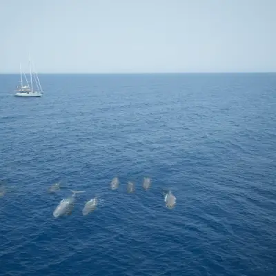
Since the late 1990s, Tethys has pioneered bio-logging in the Mediterranean Sea, starting with velocity-time-depth-recorders (TDRs) to study fin whale diving behavior in the Ligurian Sea. Since the mid-2010s, satellite tracking has been used to document movements of fin whales across the Ligurian Sea, the Gulf of Lion, the Spanish Migration Corridor in the Balearic Sea, and the Strait of Sicily. These data revealed strong links between whale behavior and environmental productivity, helping identify priority areas for protection that often lie outside currently managed zones. Since 2024, satellite tagging has been applied also to sperm whales in the Hellenic Trench, Ionian Sea, Greece.
Since 2015, the Telemetry Lab has contributed to international research efforts in Antarctica, participating in projects involving satellite tracking and biopsy sampling. Research activities included tagging Type-C killer whales (Orcinus orca) in Terra Nova Bay (Ross Sea) in 2015 and fin whales around Elephant Island, northeast of the Antarctic Peninsula in 2022.


On May 12th, 2025, the Tethys Telemetry Lab co-organized a workshop on “Advances in Marine Mammal Telemetry”, together with CIRCE, CIMA Research Foundation, IWC, and ACCOBAMS during the 36th Annual Conference of the European Cetacean Society (ECS). The event focused on best practices in bio-logging techniques (including satellite tagging) and data analysis, with particular attention to animal welfare, regulatory frameworks, and future directions for telemetry-based conservation.
The Tethys Telemetry Lab collaborates with “Protecting Blue Corridors”, a WWF global initiative that brings together 30 years of satellite tracking and scientific data to map critical habitats and migratory routes in all the world’s oceans. This massive project supports regional and international conservation efforts by identifying key threats, offering mitigation advice, and promoting science-based solutions for policymakers.

 https://www.tethys.org/wp-content/uploads/2025/12/telemetry-hellenic-trench.webp
1607
2000
ElenaTri
https://tethys.org/wp-content/uploads/2026/01/logo-Tethys-40-years.png
ElenaTri2025-12-26 09:04:282026-01-19 15:37:56Hellenic Trench
https://www.tethys.org/wp-content/uploads/2025/12/telemetry-hellenic-trench.webp
1607
2000
ElenaTri
https://tethys.org/wp-content/uploads/2026/01/logo-Tethys-40-years.png
ElenaTri2025-12-26 09:04:282026-01-19 15:37:56Hellenic Trench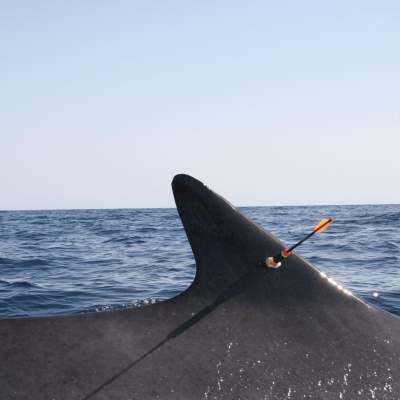 https://www.tethys.org/wp-content/uploads/2025/12/Bio-logging-Denia-feat-image.jpg
1816
2000
ElenaTri
https://tethys.org/wp-content/uploads/2026/01/logo-Tethys-40-years.png
ElenaTri2025-12-26 08:58:252025-12-26 11:49:00Bio-logging Denia
https://www.tethys.org/wp-content/uploads/2025/12/Bio-logging-Denia-feat-image.jpg
1816
2000
ElenaTri
https://tethys.org/wp-content/uploads/2026/01/logo-Tethys-40-years.png
ElenaTri2025-12-26 08:58:252025-12-26 11:49:00Bio-logging Denia https://www.tethys.org/wp-content/uploads/2025/12/Mediterranean-mobula-feature-image_MGAB.jpg
934
1422
ElenaTri
https://tethys.org/wp-content/uploads/2026/01/logo-Tethys-40-years.png
ElenaTri2025-12-26 10:24:242025-12-26 11:45:19Mediterranean Mobula
https://www.tethys.org/wp-content/uploads/2025/12/Mediterranean-mobula-feature-image_MGAB.jpg
934
1422
ElenaTri
https://tethys.org/wp-content/uploads/2026/01/logo-Tethys-40-years.png
ElenaTri2025-12-26 10:24:242025-12-26 11:45:19Mediterranean Mobula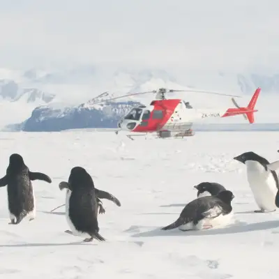 https://www.tethys.org/wp-content/uploads/2025/12/telemetry-antartica.webp
1333
2000
ElenaTri
https://tethys.org/wp-content/uploads/2026/01/logo-Tethys-40-years.png
ElenaTri2025-12-26 09:07:542026-02-05 22:20:44Antarctica 1 (Ross Sea)
https://www.tethys.org/wp-content/uploads/2025/12/Mediterranean-mobula-feature-image_MGAB.jpg
934
1422
ElenaTri
https://tethys.org/wp-content/uploads/2026/01/logo-Tethys-40-years.png
ElenaTri2025-12-26 10:24:242025-12-26 11:45:19Mediterranean Mobula
https://www.tethys.org/wp-content/uploads/2025/12/telemetry-antartica.webp
1333
2000
ElenaTri
https://tethys.org/wp-content/uploads/2026/01/logo-Tethys-40-years.png
ElenaTri2025-12-26 09:07:542026-02-05 22:20:44Antarctica 1 (Ross Sea)
https://www.tethys.org/wp-content/uploads/2025/12/telemetry-hellenic-trench.webp
1607
2000
ElenaTri
https://tethys.org/wp-content/uploads/2026/01/logo-Tethys-40-years.png
ElenaTri2025-12-26 09:04:282026-01-19 15:37:56Hellenic Trench
https://www.tethys.org/wp-content/uploads/2025/12/Bio-logging-Denia-feat-image.jpg
1816
2000
ElenaTri
https://tethys.org/wp-content/uploads/2026/01/logo-Tethys-40-years.png
ElenaTri2025-12-26 08:58:252025-12-26 11:49:00Bio-logging Denia
https://www.tethys.org/wp-content/uploads/2025/12/telemetry-antartica.webp
1333
2000
ElenaTri
https://tethys.org/wp-content/uploads/2026/01/logo-Tethys-40-years.png
ElenaTri2025-12-26 09:07:542026-02-05 22:20:44Antarctica 1 (Ross Sea)
https://www.tethys.org/wp-content/uploads/2025/12/Mediterranean-mobula-feature-image_MGAB.jpg
934
1422
ElenaTri
https://tethys.org/wp-content/uploads/2026/01/logo-Tethys-40-years.png
ElenaTri2025-12-26 10:24:242025-12-26 11:45:19Mediterranean Mobula
https://www.tethys.org/wp-content/uploads/2025/12/telemetry-antartica.webp
1333
2000
ElenaTri
https://tethys.org/wp-content/uploads/2026/01/logo-Tethys-40-years.png
ElenaTri2025-12-26 09:07:542026-02-05 22:20:44Antarctica 1 (Ross Sea)
https://www.tethys.org/wp-content/uploads/2025/12/telemetry-hellenic-trench.webp
1607
2000
ElenaTri
https://tethys.org/wp-content/uploads/2026/01/logo-Tethys-40-years.png
ElenaTri2025-12-26 09:04:282026-01-19 15:37:56Hellenic Trench
https://www.tethys.org/wp-content/uploads/2025/12/Bio-logging-Denia-feat-image.jpg
1816
2000
ElenaTri
https://tethys.org/wp-content/uploads/2026/01/logo-Tethys-40-years.png
ElenaTri2025-12-26 08:58:252025-12-26 11:49:00Bio-logging Denia| id | authors | year | title | source | doi | project | type |
|---|---|---|---|---|---|---|---|
| 544 | Panigada S., Lauriano G., Zanardelli M., Pierantonio N., Donovan G., Zerbini A., Geyer Y., Druon J-N., Fossi M.C., Notarbartolo di Sciara G | 2013 | Satellite tracking of fin whales in the Pelagos Sanctuary (western Mediterranean sea) | European Research on Cetaceans 27. | TELEMETRY LAB | Conference | |
| 590 | Donovan G.P., Panigada S., Pierantonio N. . | 2015 | Satellite telemetry applied to fin whales in the Mediterranean Sea: integration to tag whales in the Sicily Straits in winter 2013. Final report. | International Whaling Commission. May 2015. 53 pp. (Unpublished) | TELEMETRY LAB | ||
| 591 | Panigada S., Pierantonio N. . | 2015 | Satellite telemetry applied to fin whales in the Mediterranean Sea. | Internal report to UNEP/MAP–RAC/SPA. Contract RAC/SPA N° 05/RAC/SPA_2015, 36 pp. (Unpublished) | TELEMETRY LAB | ||
| 592 | Panigada S., Donovan G.P., Druon J-N., Lauriano G., Pierantonio N., Pirotta E., Zanardelli M., Zerbini A. N. . | 2015 | Satellite telemetry on Mediterranean fin whales to identify critical habitats and mitigate ship strikes. | Working paper SC/66a/HIM14 presented to the IWC Scientific Committee, San Diego, CA, USA, 14pp. | TELEMETRY LAB | ||
| 593 | Panigada S., Donovan G.P., Druon J–N., Lauriano G., Pierantonio N., Pirotta E., Zanardelli M., Zerbini A. | 2015 | Satellite telemetry on Mediterranean fin whales to identify critical habitats and mitigate ship strikes. | 21st Biennial Society for Marine Mammalogy Conference, San Francisco, USA, 13–18 December 2015. | TELEMETRY LAB | Conference |